interp module
Interpolation for Ocean and Atmospheric Data
Routines and methods for interpolation of ocean and atmospheric model field, either on regular grids or rotated, multi-pole grids. For the ocean, is set for the CMCC Ocean model at the nominal resolution of 0.25 respectively.
The staggering requires different interpolators operators for scalar points at T-points and vector quantities carried at (u,v) points. For the moment a simple interpolation is carried out but a more accurate vector interpolation is under development.
The interpolation is obtained by triangulation of the starting grid and seaprate interpolation to the new grid. The weights are preserved and they can be used for repeated application of the same set of grids.
Classes
- class interp.Atmosphere_Interpolator(grid, option='linear')[source]
Bases:
objectThis class creates weights for interpolation of atmospheric fields. No mask is used.
This class create an interpolator operator to a target grid tgt_grd. The interpolator then can be used to perform the actual interpolation.
The target grid must be a xarray DataArray with variables lat and lon
- Parameters:
grid (str) -- Choice of output grids
1x1 -- Regular 1 degree
025x025 -- Coupled model grid, nominally 0.25,
option (str) -- 'linear', interpolation method
- Variables:
name (str) -- Name of the interpolator
grid (str) -- Option for the grid
option (str) -- Interpolation method
Notes
It is a thin wrapper around xarray interp_like method.
Examples
Create the weights for interpolation
>>> w= zint.Atmosphere_Interpolator('1x1','linear')
Interpolate temperature
>>> target_xarray=w.interp_f(src_xarray)
- choice
Interpolation method selected linear or nearest
- Type:
str
- name
Name of the Interpolator
- Type:
str
- tgt
Target grid
- Type:
xarray
- class interp.Ocean_Interpolator(src_grid_name, tgt_grid_name, level=1, verbose=False, window=3, period=1)[source]
Bases:
objectThis class creates weights for interpolation of ocean fields.
This class create an interpolator operator from a source grid src_grid to a target grid tgt_grd. The interpolator then can be used to perform the actual interpolation. The model uses an Arakawa C-grid, that is shown in the following picture. The f-points correspond to the points where the Coriolis terms are carried.
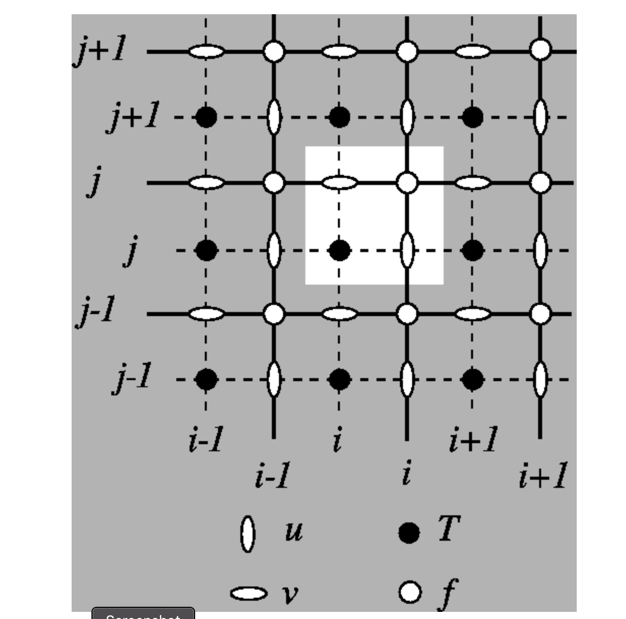
The Arakawa C-grid used in the ocean model show also the ordering of the points, indicating which points correspond to the (i,j) index.
The source grid must be a xarray DataSet containing coordinates latitude and longitude.
The target grid must be a xarray DataArray with variables lat and lon
Border land points at all levels are covered by a convolution value using a window that can be changed in sea_over_land.
Works only on single DataArray
- Parameters:
src_grid (xarray) -- Source grid
tgt_grid (xarray) -- Target grid
level (float) -- Depth to generate the interpolator
window (int) -- Window for sea over land
period (int) -- Minimum number of points in the sea-over-land process
verbose (bool) -- Lots of output
- Variables:
tgt_grid -- Target grid
mask -- Mask of the target grid
vt -- Weights
wt -- Weights
mdir -- Directory for masks files
ingrid -- Input Grid, src_grid_name
outgrid -- Output Grid tgt_grid_name
window -- Window for convolution Sea-Over-Land (default 3)
period -- Minimum number of points into the window (default 1)
T_lon -- Longitudes of input T-mask
T_lat -- Latitudes of input T-mask
U_lon -- Longitudes of input U-mask
U_lat -- Latitudes of input U-mask
V_lon -- Longitudes of input V-mask
V_lat -- Latitudes of input V-mask
tangle -- Angles of the T points of the input grid
mask_reg -- Mask of the Target grid
cent_long -- Central Longitude of the Target grid
name -- Name of the Interpolator Object
level -- Level of the Interpolator Object
- Interp_T :
Interpolate Scalar quantities at T points
- Interp_UV :
Interpolate Vector Velocities at (U,V)
- mask_sea_over_land :
Mask border point for Sea over land
- UV_sea_over_land :
Fill U,V values over land
- to_file :
Writes interpolator object to file (pickled format)
Examples
Create the weights for interpolation
>>> w= zint.Ocean_Interpolator(src_grid,tgt_grid)
Interpolate temperature
>>> target_xarray=w.interp_T(src_xarray,method='linear')
Interpolate U,V
>>> target_xarray=w.interp_UV(U_xarray,V_xarray,method='linear')
- mdir
- ingrid
- outgrid
- window
- period
- T_lon
- T_lat
- U_lon
- U_lat
- V_lon
- V_lat
- name
- level
- tangle
- mask
- masktb
- maskub
- masku
- maskvb
- maskv
- latlon
- sea_index
- masT_vec
- tri_sea_T
- sea_index_U
- tri_sea_U
- sea_index_V
- tri_sea_V
- mask_reg
- cent_long
- latlon_reg
- sea_index_reg
- regmask_vec
- interp_T(xdata, method='linear')[source]
Perform interpolation for T Grid point to the target grid. This methods can be used for scalar quantities.
- Parameters:
xdata (xarray) -- 2D array to be interpolated, it must be on the src_grid
method (str) --
- Method for interpolation
'linear' , Use linear interpolation
'nearest' , use nearest interpolation
- Returns:
out -- Interpolated xarray on the target grid
- Return type:
xarray
- interp_UV(udata, vdata, method='linear')[source]
Perform interpolation for U,V Grid point to the target grid. This methods can be used for vector quantities.
The present method interpolates the U,V points to the T points, rotates them and then interpolates to the target grid.
- Parameters:
udata,vdata (xarray) -- 2D array to be interpolated, it must be on the src_grid
- Returns:
out -- Interpolated xarray on the target grid
- Return type:
xarray
- mask_sea_over_land(mask)[source]
Mask border point for Sea over land.
Sea over land is obtained by forward and backward filling NaN land value with an arbitrary value, then athey are masked to reveal only the coastal points.
- Parameters:
mask -- original mask
- Returns:
border mask
- Return type:
border
- fill_sea_over_land(U, u_mask)[source]
Put values Sea over land.
Using the mask of the border points, the border points are filled with the convolution in 2D, using a window of width window, here The min_periods value is controlling the minimum number of points within the window that is necessary to yield a result.
They can be fixed as attributes of the interpolator
- Parameters:
U -- Field to be treated
u_mask -- Mask for the field
- Returns:
Filled array
- Return type:
U